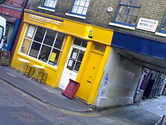
At this very moment I’m sitting at the table just inside the door at The Breakfast Club on D’Arlbay Street in Soho, London.
You’d know this already if, like MisterSnappy, you were one of my flickr contacts and had seen the photo I took on my way here this morning.
And, thanks to a service called Plazes that a friend recommended the other day, stalking my every movement is about to become even easier. Not that I like to encourage such things.
It works both ways – I can see on my phone the 10 other Plazes users within 2km of my present location and, on the website, the dozens of people across London who are already using the service.
The map below showed my location – at The Breakfast Club – at the time I posted this but will continue to update so, when you come across this post, it should show you my present location. And, of course, if I switch off the service or stop using it it probably won’t show my location at all.
My phone has an external GPS that uses software called co-pilot. When I got the phone, I tried to figure out how to publish the map, accessible via password, onto my blog. I never did figure out how to achieve that but Plazes does the same thing and more.
I’ve been using zonetag to geo tag my flickr photos for a few months now and twitter to post short messages about what I’m up to. It’s strange to think that I’m willingly allowing myself to be tracked at such a level of detail. I’m stilling trying to figure out why… (?!)

Looks like an interesting app, I’ll have a play with it over the weekend. Like you I’m not sure what this sort of LBS is really for, but it looks fun enough and I’m always on the lookout for alternative flickr uploaders.
Here’s what I’m running on my N70 these days. http://planetmike.blogspot.com/2007/04/whats-on-my-phonemore-adventures-beyond.html